Haystack of Ray Brook


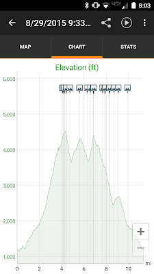
Track/Trail from AllTrails app

Trailhead: McKenzie/Haystack Trailhead, Rte. 86, Ray Brook, NY
Distance: 7 miles (AllTrails); 6.6 miles (Guidebook)
Difficulty: Moderate/Hard
Date: 8/20/2016

We are ON A ROLL!  Louise and the boys have now been hiking three weekends in a row!  I've joined them for the last two to Goodman and today to Haystack (not the high peak).  Having completed the Tupper Lake Triad, it was time to move on to its bigger, meaner brother, the Saranac Lake Six.  We've already done Baker Mtn. twice (sorry, no blog posts) and I've done McKenzie, Ampersand, and St. Regis (almost twice) on other trips.  We (I) decided that with a beautiful weather forecast, and the upcoming return of students to Clarkson University, where I work, today was the day to try Haystack.

We were on the trail, dogs and all, at 10AM.  The trailhead is right along rte. 86 in Ray Brook, on the way to Lake Placid. There were a few other cars in the lot, but nothing crazy.  The trail is, as advertised, easy to start, and we banged out the first 2.4 miles in about an hour and a little more, without any breaks.  This section of the trail gradually creeps along up and down until about 1.8 miles, when it starts a gradual uphill along Little Ray Brook.  This section of the trail is serene and beautiful, with small waterfalls punctuating the small stream's steady babble as you gradually hike along its length.

Ruins below the junction
Old dam and small reservoir


Just before the trail junction where one goes right to McKenzie and left to Haystack, there are some ruined foundations from an earlier age. Immediately after the junction there is a small dam and reservoir. At this point the trail starts to climb in earnest and the going started to get pretty tough.  But with less than a mile left to the summit, spirits remained high.

The family climbing one of the steeper sections

Views of the High Peaks
Views of the Ray Brook Prison and Western High Peaks

As one gets closer and closer to the summit, the trail gets steeper and steeper, eventually becoming very steep, but the views also start to show up as the tree cover thins. Once this happens, the summit appears quickly.  It is a moderately sized bare face looking to the south and east, with a beautiful panorama of the High Peaks Wilderness.  But it is not the 360 degree view that we have had on some other trips (Colden, McIntyre Range).

Panorama, with moving people pixelating
After a brief rest on the summit, I went looking for views of McKenzie Mtn., but couldn't find a good opening in the trees to get a good look.  I returned to eat lunch and rest up before heading back down. All in all it took us 5 hours to get up and down the mountain, including a relatively long rest at the dam to refill water bottles. Everyone enjoyed the hike, not least our two dogs.

Scooby

Gigi

With another peak in our pockets, we began the drive home, but before getting too far, we stopped, as usual, for Donnelly's Ice Cream where we got a big surprise - today's flavor was Black Cherry twisted with Blackberry.  It was delicious.


Goodman Mountain and the Tupper Lake Triad

View of Coney Mountain and south from Goodman

Trailhead: Goodman Mountain, south of Tupper Lake on Rte. 30
Distance: Total 3.5 miles
Difficulty: Easy
Date: 8/14/2016

There is some great short hiking near Tupper Lake, NY.  We have previously hiked Arab Mountain (to the west of Tupper Lake) on a number of occasions (most notably, this time).  That is a short hike with a few steep sections and with beautiful views from its fire tower.  We have also hiked Coney Mountain a couple of years ago while staying at Lake Eaton Campground. That is another short hike, this time to a bald peak (no fire tower).  In early August, while I was off galavanting around Southern California with friends watching baseball, my wife, boys, and dogs, did another climb of Arab and heard from the steward about the Tupper Lake Triad and the third of the peaks, Goodman Mountain. Excited about the prospect of completing a list (even one we didn't previously know about) and with a trip to Fish Creek Ponds planned for the next weekend, it was clear what had to be done.


So, after a couple of days of off and on rain showers at Fish Creek, on Sunday the 14th the sky seemed to clear and we made our plan to climb Goodman Mountain.  The trailhead is well-marked, with plenty of parking, and the trail itself is handicapped accessible for about a quarter of a mile.  In fact the trail is paved and mostly flat for nearly an entire mile before turning sharply to the left and heading up hill.  At that point there is a set of stone stairs and the trail climbs steadily (but not too steeply) as it winds its way around the northeastern side of the mountain and then up to the summit. It was pretty easy going the whole way.

All of us (minus our picture-taker) at the top

At the summit (about 1.75 miles from the trailhead), there are good views to the south (unfortunately not to the north towards Tupper Lake), and on the beautiful Sunday morning that we were there, our views were nearly endless.

Like the other two Triad peaks, this one is an excellent short day hike (2 hours) and would work well for any child two years old or older.  In fact, the Triad would be very doable for most people in a single day.  If coming from the North (Potsdam, Canton and environs) I would start at Arab, eat lunch at the Main St. Restaurant, then head to Coney and Goodman which are practically right next to each other.

Unfortunately, on this day, as we earned our patch, the True Value hardware store in Tupper Lake was closed, so we couldn't get our patches, but we can't wait to drive through again to pick them up - one for everyone, even the dogs!

Summer and Winter Patches


The AllTrails track


Colden via Arnold Lake Trail and the Marcy Brook Lean-to

Colden from its North Summit


Trailhead: ADKs Adirondack Loj, near Lake Placid, NY
Distance: Total 13.5 miles or so
Peaks: Colden (#11, 4,714 ft.)
Difficulty: This is a long hike for a day, but an easy hike for 2 or 3 days.  The climb to Colden is easy as ADK peaks go
Date: 7/25/2016-7/26/2016

Colden is one of the most recognizable, and visible peaks in the ADK high peaks.  It sits between the McIntyre Range and the Great Range, and its large and numerous slides on its west side make it stand out.  Because of its location, it can be seen from most of the other high peaks.  This also means, that from its summit, one can see nearly all of the high peaks region.  I have wanted to summit Colden for years, but have always been scared off by the steep Lake Colden trail to the top.  The Lake Arnold trail, on the mountain's Eastern side is much is less steep, but offers the same rewards.

With my 8 and 12 year old boys, I am always looking for accessible high peaks to conquer, and Colden fits the bill.  We planned a 2-3 day trip, staying at the Avalanche Lean-to, with the attempt on Colden's summit scheduled for the second day. My oldest conquered his first backpacking trip last year and was excited for another.  My younger son was less sure about backpacking, but agreed to go along and test it out.  When we left the trailhead at the Adirondack Loj at 9:30 on Monday morning, spirits were high.

At the ADK Loj Trailhead
View of Marcy Dam, looking South


The weather forecast was calling for afternoon thunderstorms, and the radar in the AM was looking menacing.  So, we tried to get an early start and move relatively quickly. The trail from the Loj to Marcy Dam is mostly flat and well-maintained. We made it to Marcy Dam around 11 and as we crossed the bridge below the dam, the rain began to fall.

The new bridge below Marcy Dam


We ducked into the Marcy Dam lean-to #2 to eat our lunch and waited out that first rain shower. As the rain slowed down, we got moving and headed up the trail towards the Avalanche lean-to.  We got there around Noon, only to find that at least two people were already staying there and, against regulations, had set up their tent inside the lean-to.  We debated trying to crash with them before deciding to head back down the trail towards one of the 3 or 4 other lean-tos further back towards the dam.

The next lean-to we came to was the Marcy Brook lean-to, about a tenth or two of a mile down from the Avalanche Lean-to.  There were too women there, but they were planning to leave, so we squatted in the lean-to out of the rain and settled in.  We spent the afternoon reading, napping, and playing cards, so, frankly, time well spent. Then we prepared our freeze-dried dinner to eat by the shore of Marcy Brook and finished with Freeze-dried Ice Cream Sandwiches (tasted good, but with the consistency of cardboard).


The next morning, we got going with our traditional breakfast of instant oatmeal and were on the trail by 7:30.  The trail from Marcy Brook lean-to starts gently, but gradually increases in difficulty as the eroded trail becomes more and more an adventure of rock-hopping. It is still a pretty easy 1.7 miles up to Lake Arnold, which made for a great place for a scenic snack break.

Snacks on Lake Arnold


From there, the trail gets steeper as it climbs up to Colden's ridge and eventually to the North Summit.  As ADK high peaks trails go, however, it is not a particularly challenging climb.  There are only a few places where one needs to scramble or climb over rocks, and there are several sections where it flattens out for a little rest. The trail opens up at the North Summit as you ascend above treeline, and you get beautiful views of Lake Placid, the McIntyre Range, and Colden itself.  From here, the trail descends to a col before beginning the ascent to the true summit.  The trail itself has gotten a lot of trail work in recent years, and is in excellent condition with ladders over most of the rocky stretches, making for a very easy final ascent.

A long ladder climbs at least 3 stories


Just below the summit, there is a neat little area where the trail goes under an overhanging boulder through something resembling a small cave.  This is a great landmark indicating that you are near the top, and great fun for kids.

A "cave" just below the summit ridge

After that, you reach the summit ridge itself.  In the case of Colden, the best views are found along rock ledges that surround the actual summit, as the summit itself is surrounded by small trees that limit the views.  But, as I mentioned above, these ledges allow views of nearly every peak and region in the High Peaks.  I was able to identify Marcy, Gray, Skylight, Algonquin, Iroquois, Wright, Marshall, Big Slide, Giant, the Wolfjaws, and Gothics.  It was great to see the mountains layered upon each other with low clouds hanging over the scene.

The south end of the McIntyre Range

Flowed Lands and Lake Colden
Marcy, Gray, and Skylight (in the clouds)
The actual summit, helpfully labeled
Algonquin, emerging from the clouds
Erik and me, literally on the summit

After thoroughly enjoying the summit views, we headed down, grabbed a snack in the cave, and then headed down the mountain in earnest.  We then stopped again at Lake Arnold for lunch and a quick refill on our water bottles.  The hike down went a little slower than hoped as we negotiated the rocks (with the exception of Erik, who loved the natural obstacle course and occasionally had to be reined in).  We finally got back to the lean-to around 2:15.  We took a 45 minute break, including soaking our feet in the brook, before making the decision to make it a 2-day trip rather than 3 and begin our hike out to the Loj.  After packing up, we hit the trail at 3:50, and arrived back at the Loj by 5:35, chanting our mantra as we went, "Pizza, Donnelly's (Ice Cream), Chocolate Cake."  That is, pizza at Little Italy in Saranac Lake, Red Raspberry Twist soft ice cream at Donnelly's, and a homemade chocolate cake that my wife had made to tempt us home.  Quite the incentive!  At the end of the day, we had hiked 10 miles, and were feeling it.  Nonetheless, we were all proud, and were able to smile as we held up our Mt. Colden patches!


View of Marcy Dam from below


All in all, Colden is a beautiful mountain, relatively easy to climb, and a great adventure for adults and kids alike.  It is my favorite mountain so far in the high peaks (I've now climbed 19 of the 46), and I look forward to climbing it again in the future!

The McIntyre Range

Algonquin Peak, viewed from Wright Peak


Trailhead: ADKs Adirondack Loj, near Lake Placid, NY
Distance: 10.2 miles (book/map descriptions), 10.5 miles (estimated by phone)
Elevation Change: ~3776 ft.
Peaks: Wright Peak (#16, 4580 ft.); Algonquin (#2, 5114 ft.); Iroquois (#8, 4840 ft.)
Difficulty: This is a difficult hike, although with only a few very steep sections.  Mostly it is just a hard hike, rather than a scramble
Date: 7/23/2016

About 6 weeks ago, I was discussing my peak climbing aspirations in the Park with some parents at my son's little league baseball game.  Overhearing the conversation, Abrahm DiMarco approached me and said, "if you make plans to do any hikes this summer, let me know."  I fear that he is now regretting those words.  Capitalizing on this opportunity for a new hiking partner, I quickly had us set aside a date to hike the McIntyre Range - a long day-hike over three high peaks - and a hike for which my sons are not quite ready.

After a one day delay due to an intimidating weather forecast, we set out from Potsdam at 6:30 on a sunny Saturday morning, heading for Lake Placid and the Adirondack Loj trailhead. We were there by 8:15 and on the trail, signing in, at 8:22 AM (Abrahm is a military man, and is very precise about our times).  The forecast was still threatening thunderstorms for later in the afternoon, so we were glad to have gotten an early start. We were well-supplied with water, having read the tale of my co-author's ADK Death March.

We set out down the Van Hoevenberg Trail which can take you nearly anywhere in the Eastern High Peaks region.  After a mile, we turned slightly to the right to follow the Algonquin Peak Trail. The trail is rocky from beginning to end, being a great example of the damage that trails and hikers due to a landscape, but begins at a quite reasonable pitch and becomes "progressively steeper," to quote the High Peaks Trails guidebook.  The next landmark comes shortly after as the trail crosses the Whale's Tail Ski Trail, and then ascends to McIntyre Falls, which is probably beautiful, when there is water. Our hot and dry summer of 2016, however, left it quite barren, unfortunately.

McIntyre Falls (?)
After this, the trail continued to steepen towards the intersection with the Wright Peak Trail.

Wright Peak Trail Intersection


I expected, naively perhaps, that as the lowest of the three peaks on our schedule, it would also be the easiest.  We were, however, clearly wrong.  The short 0.4 mile ascent to Wright from the Algonquin Peak Trail was steep and open, with some significant scrambling. The view from the top, however, was beautiful, well, except for my hiking partner.

Panorama from Wright Peak to the North and East

Colden was prominent in our views nearly all day


Wright Peak is well known for being the site of a 1962 plane crash. We couldn't find the plaque associated with the crash, but did see what remains of the wreckage just below the summit.


Wreckage
We snacked in a slightly sheltered area just below "tree" line, made some boot adjustments, and also prepared ourselves for a change in plans.  If the remaining climb to Algonquin was as hard as what we had just done we might have to give up on Iroquois.  Then we were back on our way to Algonquin. From Wright, Algonquin has a few very steep and rocky sections, but is mostly more moderate.  We did, however, fall for more than a few false summits, thinking we were almost there only to see a further peak just beyond.

A steep section climbing up to Algonquin
Indian Pass and views to the west from the climb up Algonquin

Once on Algonquin, however, the views were worth it.  The summit steward was also an excellent resource and a source of positive-thinking with her contagious smile. She helped us think through our plans to go over to Iroquois, whether or not we should consider a loop hike through Avalanche Pass (following the above-mentioned Death March route - the answer was a resounding "No"), and what the immediate weather forecast looked like to her.  Following this conversation we retreated to eat our lunches and discuss our plans.  Following my statement that "If I don't do it today, I'll have to do the whole hike another time" Abrahm reluctantly agreed to add the 1.5 hour round trip hike over to Iroquois Peak, all the while being sure to blame me, in advance, for anything that went wrong.


Panoramas from the top of Algonquin


After lunch, we took off down Algonquin and across two small intermediate summits that lie between Algonquin and Iroquois.  The trail, though not "officially" maintained by DEC was largely in good shape, with a number of boardwalks across what could be swampy areas.  The trail was also almost entirely above treeline, making for beautiful scenery.

Flowed Lands and South, viewed from Iroquois
Yours truly on Iroquois, with Algonquin in the background

Once atop Iroquois, we raced quickly back to Algonquin, talked some more with the steward, this time about my upcoming plans to climb Colden with my two sons, and then after a quick snack began to race the weather back down to the Loj. With about 2.5 miles to go, we began to hear thunder, and were briefly rained upon as a large line of storms was moving over portions of the Adirondacks. None the worse for the wear, at least from a rain perspective, we made it back to the car, and were changing shoes and shirts for the ride home when the storm hit in earnest and the hail began to fall. We had just made it in time.

Deciding not to inflict our stench on unwitting bar patrons, we began our drive home, making one stop that is becoming a high peaks tradition for me - Donnelly's Soft Ice Cream outside of Saranac Lake.

Overall, this was another great hike in the high peaks.  These three peaks represent numbers 16, 17, and 18 on my slow quest to have climbed the 46.  Hopefully Abrahm will agree to come along for some more!

Algonquin from the descent of Iroquois.  Note the boardwalks on the trail on the left side of the photo


Giant Mountain, Rocky Peak Ridge, and the Nubble

     View of Giant from the Giant's Nubble


Trailhead: Giant/Roaring Brook, St. Hubert's, NY
Distance: 11.36 miles (GPS), 10.9 (book/map descriptions)
Elevation Change: 5343 ft.
Peaks: Giant Mountain (#12, 4627 ft.); Rocky Peak Ridge (#20, 4420 ft.); Nubble (2760 ft.)
Difficulty: Most stretches are only moderately difficult, with a few steep or very steep sections

I don't want to oversell this hike, but......actually, nevermind: this was a GREAT hike.  The trails were in excellent condition, the weather was perfect, the people were friendly, and the scenery was beautiful.  Not only that, but this area, the Giant Mountain Wilderness, has so much potential for future trips.  I discovered so much on this trip that I wasn't expecting, and I will definitely be back for more.

My hike, portrayed in Google Earth

Over the many years that my family and I drove back and forth from Northern New Jersey to our home in Potsdam, NY, we often remarked on the very high waterfall visible from the road just before St. Hubert's, never knowing if there was a way to get closer.  So, it was with delight that, in preparation for this trip, I read that there is a trail to these falls at the Giant/Roaring Brook Trailhead. I started this hike with the 0.2 mile detour over to the base of the Roaring Brook Falls.  While the view wasn't much given the hot and dry late summer that we have had, I was still impressed by the potential of these falls given their great height and narrow cataract through the rock.


Looking up at Roaring Brook Falls

After returning to the main trail, I began the .4 mile hike up to the top of the falls, which offered the first view of the High Peaks wilderness across Rte. 73 from Giant Mountain.

First views of High Peaks from the top of Roaring Brook Falls

At this point the trail begins the ascent towards Giant.  The trail was hard packed dirt, and was very well-maintained.  In several places the trail had been graded with rocks or, in one spot, a ladder had been added.

Excellent examples of trail workmanship

One of my concerns going into this hike had been boredom.  That may sound crazy, but I hadn't hiked alone in a long time, and never for this length.  I am used to talking with my companions as I hike, but on this hike I wouldn't have that conversation to pass the time.  Thankfully, on such a beautiful late August day, I had plenty of other hikers on the trail, and spent about 2 miles of this climb conversing nicely with a 46er who was climbing this particular route for the first time.  It is so nice to be able to chat casually with someone with many of the same interests.  

After a little more than 3 miles, I reached the intersection with the Ridge Trail, the other primary entry point for Giant Mountain.  Here I ate my lunch and took a short break before heading up the last .7 miles to Giant.  These last .7 miles include a few short sections of exposed rock slabs, but are not too challenging.  Considerably less challenging than sections on Cascade, for the most part.  There are a few open views but nothing really spectacular.  After passing the junction for the trail to Rocky Peak ridge, it is a short easy climb up to the summit of Giant, where the views speak for themselves.  

     Panorama from Giant's peak

View of the valley communities from Giant Mountain

After a quick break and more snacks, I headed down to the junction and began the 1.3 mile hike over to Rocky Peak Ridge.  The section of trail to the col between the two peaks is by far the steepest section of trail I encountered on this day.  Lots of exposed rock slabs.  As I went down I was forced to confront what it would be like to come back up!  Thankfully, I did get some views of my destination along the way.  

Rocky Peak Ridge viewed from the descent of Giant

The brief uphill section to the top of Rocky Peak Ridge was mercifully much more gentle, and after less than an hour from Giant, I made it to the top of Rocky Peak Ridge.  One hiker coming down made clear to me that not only was the trip to RPR worth it, but that the views were better than Giant. She was right.  Also, she warned me, "just don't look back at the climb back up to Giant," and that was good advice as well, that I failed to observe.  

View looking back at Giant from Rocky Peak Ridge

Panorama from Rocky Peak Ridge, towards the High Peaks and Giant

Panorama from Rocky Peak Ridge towards Lake Champlain and Rocky Peak

While the view from Giant is mostly to the West and North, the views from Rocky Peak Ridge are in all directions and include great views not only of the High Peaks, but also of Lake Champlain and points east and south.  Definitely worth the hike over from Giant.

After resting some and refueling, I began the trek back to Giant.  Noticing that I was down to about a half liter of water, I thought about continuing away from Giant to Marie Louise Pond to filter some more water, but decided that the extra 1.2 miles roundtrip was not going to be worth it.  I think I made the right call, but I was definitely thankful when I finally got back to Roaring Brook and was able to refill my bottles, several hours later.  

The ascent of Giant from Rocky Peak Ridge certainly lived up to my fears, and there were a few stretches where I was just managing to put one foot in front of (or above) the other.  After this hard climb I rested some more at the junction with the Ridge Trail, and noticed a strange feeling.  As I began the descent I realized that I was already feeling sad to be heading down, rather than spending more time in this beautiful section of wilderness.  In the interests of exploring as much of the area as I could, when I got to the fork with the Ridge Trail to the left and the Roaring Brook Trail to the right, I decided to head down the Ridge trail to make something of a loop of the rest of my hike, rather than going down the same way I had come up.  The 1.1 mile stretch of the Ridge Trail down to the Nubble trail made for some gorgeous hiking.  Lots of exposed rock with beautiful views to the West and South.  

views from the Ridge Trail


At one point the trail divides into so that hikers can go either over or around "the bump."  Again, in the interest of learning as much as possible, I chose to go OVER the bump.  While the views were nice, they offered little that was unique given the many other exposed areas.  


It was also in this stretch that I encountered that rarest of Adirondack creatures, the switchback! Thankfully, this relatively steep trail was made easier by using several switchbacks along the side of the mountain. I was sure to make note of this on my GPS track to show my son later....the lack of switchbacks is one his "favorite" things about ADK hiking.  

Finally, I arrived at the junction with the Nubble trail.  I finished off my water, and had an additional snack before resuming the climbing portion of my day with an ascent of the admittedly small peak between Giant and the pond known as Giants Washbowl.  I struggled with this choice briefly, deciding between this climb and continuing down to cross on the washbowl trail itself (where I would also be able to fill my water bottles).  Alas, the draw of more views, including some of the Giant itself proved too tempting.  This was a great decision.   

The nubble was only about .5 miles from the Ridge Trail, and the climbing was gentle.  I met more friendly hikers and shared the trail with them for this short section.  After a great little vista with views of Chapel Pond and its cliffs and the wash bowl, the trail continued up to the Nubble itself which has spectacular 360 degree views of Giant Mountain and the High Peaks Wilderness.  

Panorama from Nubble

Giant Mountain from the Nubble

Washbowl and Chapel Pond cliffs

Once I began the descent from the Nubble to the Roaring Brook Trail and then to my car, with nothing more to look forward to, my knees and legs began to really let me know how they felt about all the hiking I had done!  I still had nearly 2 miles to go, and my legs were not happy!  The descent to Roaring Brook is somewhat steeper than that to the Ridge Trail, which made for challenging hiking on tired legs.  

After a little less than a mile, I made it to roaring brook, refilled my water bottles (and drank from them generously) at a beautiful pool and then headed down to my car.  

The Giant Mountain wilderness is a spectacular area to which I will return!  I have been intrigued by Giant for years, in fact, before I had even moved to NY I had gotten this particular mountain in my head.  It lived up to every expectation that I had.  Even more than this trip though, I am excited by the possibilities for future hiking.  An excellent short hike with kids would be to park at Roaring Brook, see the falls in high water, and then head up to the Nubble, looping back by the wash bowl.  This would be about a 3.5 mile loop with only a little bit of tough climbing.  For those kids who want to be bagging high peaks, I recommend the Roaring Brook approach over the Ridge Trail.  While it is not as scenic, it is a gentler, if slightly longer, climb that I think will prove less exhausting for kids.  It also has no large rock slabs that would require little ones to be boosted!  Of course, if your kids are like one pair I saw on this trip, doing their 16th and 17th high peaks, of THE SUMMER, then by all means, the Ridge Trail may be for you.  

In case it hasn't been made clear, I highly recommend this small network of trails.  Some of the best trails I have been on in the Adirondacks.  Enjoy! Oh, and if you are heading back north afterwards, don't forget to stop at the Noonmark Diner for dinner and pie and Donnelly's Ice Cream in Saranac Lake for second dessert.  What, you've never heard of second dessert?  Well, I guess you just haven't been hiking hard enough then.